Categories
Milestones Events Projects

Put Your Pub on the Map!

Put Your Pub on the Map!

Welsh Gov’s Welsh map can be edited by You…

If you believe that your local is the best local, or that the new extension-on-the-extension of your pub needs to be on the map, this is your opportunity to make sure it’s there for all to see.  OpenStreetMap is the Wikipedia of the mapping world, and a Welsh project is now eager for people in Wales to put their pub on their Welsh version of the map.  One of the first pubs to be added already is Tafarn yr Iorwerth on Ynys Môn…

Saturday 9th March saw Welsh Government’s ‘Mapio Cymru’ [Mapping Wales] project organise a day of sharing good practice and conversation in Tafarn yr Iorwerth (previously known as the Iorwerth Arms) in Bryngwran on Sir Fôn.  The location was chosen as it recently had its Welsh name added to Mapio Cymru’s openstreetmap.cymru, the official Welsh-language online map of Wales, an important part of the national Data Map Wales project.

‘Mapio Môn’ was an opportunity for mapping enthusiasts to meet up to see what can be done to improve the provision of Welsh-language names on maps.  Experts from the Welsh Place-name Society, Transport for Wales and from the community-run pub Iorwerth Arms itself shared ideas which could support the long-terms aim of Mapio Cymru – i.e. to make Welsh-language data equal in quality and quantity to the English-language data already available for Wales.  This data could then be used freely in future mapping apps and services from any provider; across education, tourism, fitness, gaming, sustainability, and public services.

Welsh place-names have been a hot potato in Welsh-language heartlands, however Ordnance Survey use the official Welsh-language names too, as Steve Roddick, Welsh Place-name Society member Steve Roddick explained on Saturday:

“The Cable Bay name will be recorded, but it’s in the metadata of the digital map, hidden away from the eye but visible to the computer…so if you were sitting at the end of a 999 call and you carried out an enquiry, the name would come up, you’d know the location you need to send the ambulance to… For the paper map, the one the public use, the Welsh name is always recorded in preference…[Cable Bay] is a sort of a nickname, and generally nick-names aren’t visible on the Ordnance Survey map.”

Welsh-language names of historical importance can be kept in the public eye on Cymru / Wales’ official online Welsh-language map https://openstreetmap.cymru via osm.org.  For further details on how to add local pubs and other features, follow #mapioCymru on social media or email mapiocymru@dailingual.com.  Audio highlights from the bilingual discussions will be shared online soon on mapio.cymru.


Mapio Cymru is a Welsh Government-sponsored project by Data Orchard.


Categories
Milestones

FixMyStreet are now using our map!

FixMyStreet is now available in Welsh


Welsh-speaking users of FixMyStreet, the national reporting service for local street and environmental problems, can now make reports using a Welsh-language map provided by Mapio Cymru.


Broken street lights, fly-tipping, potholes and other local, place-based issues in Wales can now be reported to the correct authority by citizens in Welsh as well as in English via FixMyStreet, the long-running reporting service for street and environmental problems provided by civic technology charity mySociety.


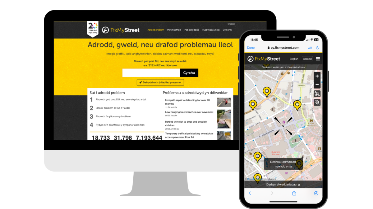
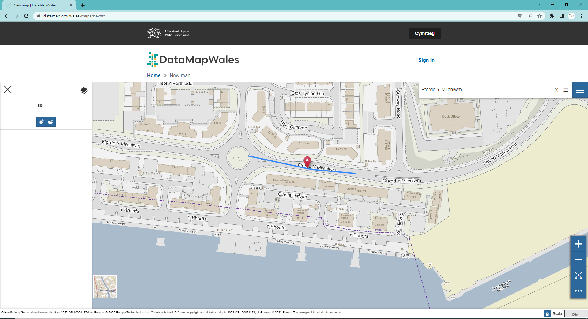
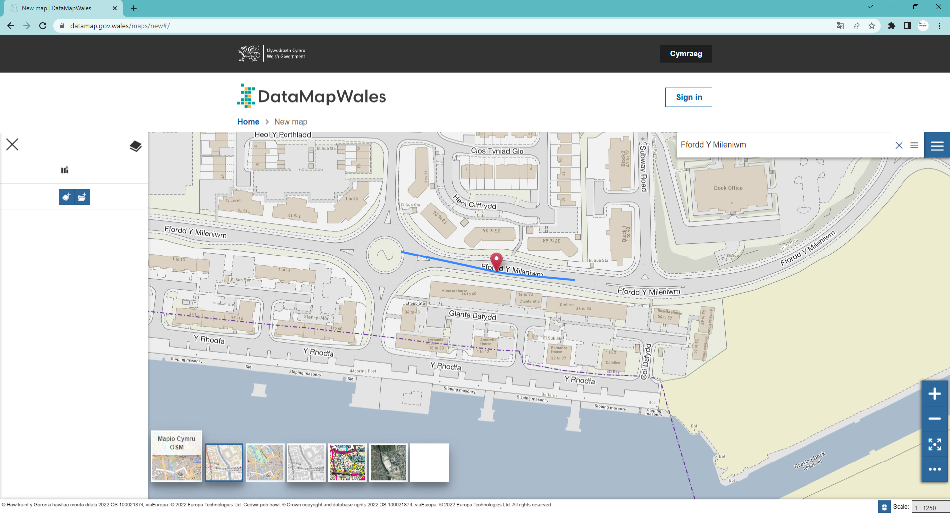
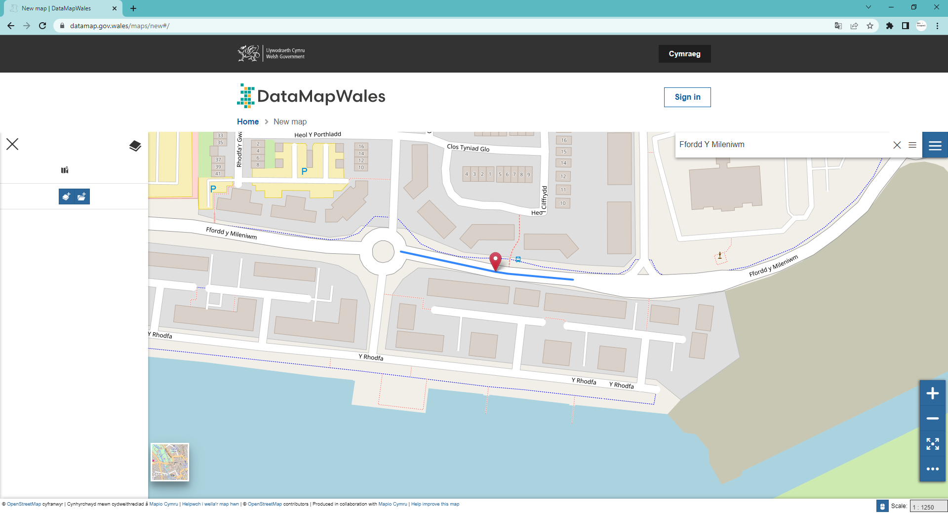
FixMyStreet is a progressive web app that enables citizens across the UK to report local problems to the authority responsible for fixing them, even if they do not know who that is. For the first time since its launch in 2007, users in Wales wanting to make reports in Welsh will be able to view a Welsh-language version of the website and app, including a Welsh-language map provided by Mapio Cymru.


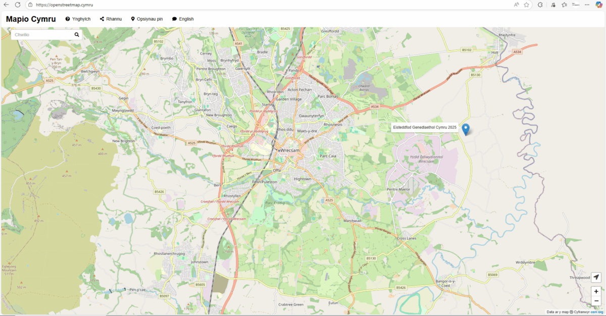
Over half a million people in Wales speak Welsh and the Welsh Government aims to double this by 2050. Having digital services that work as well in Welsh as they do in English is key to achieving this growth in the language. Launched in 2019, Mapio Cymru is a project that aims to ensure mapping services are as good in Welsh as they are in English. Using open data sources Mapio Cymru provides a Welsh-only map of Wales. It also works with organisations across Wales to improve mapping services in the Welsh language.


Louise Crow, Chief Executive at mySociety, said: “FixMyStreet was built to make it easier for citizens to report problems in their communities. We are delighted to be able to make the service accessible to Welsh-speaking citizens, with a fully translated reporting process and a Welsh-language map, enabling users to select the street names and locations with which they are familiar. We look forward to seeing the Welsh-language version of the service put to good use by more citizens who care about improving where they live.”


Ben Proctor, Innovation Director at Data Orchard CIC which runs the Mapio Cymru project, said: “Digital mapping technology is really powerful and easy for organisations like mySociety to use in English. Sadly it’s not the same in Welsh. We aim to make it easier for organisations to  deliver services on the highest quality Welsh-language mapping available.”


Welsh-speaking users can start using the Welsh-language version of FixMyStreet straight away by heading to cy.fixmystreet.com or downloading the FixMyStreet app from the relevant app store.


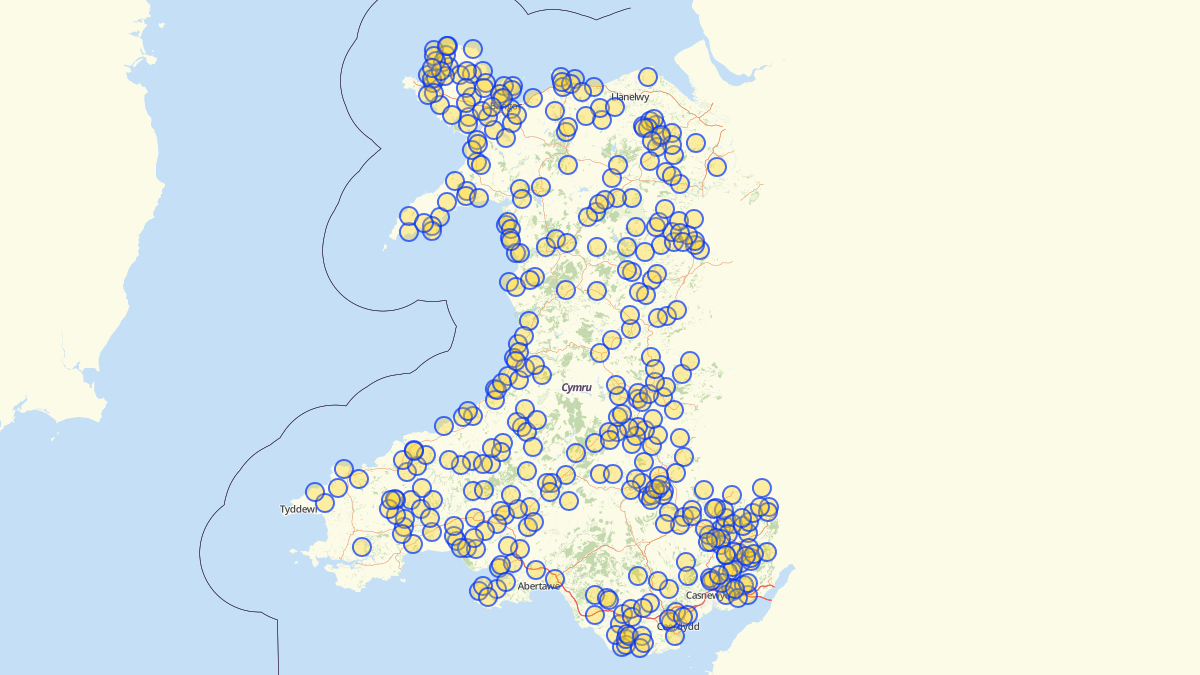
There are gaps in Mapio Cymru’s Welsh language map because the project relies on volunteers and public bodies to contribute definitive Welsh names. Volunteers can help to plug the gaps by adding the Welsh names for features on the map (buildings, roads, mountains, fields and so on). Public bodies can help to plug the gaps by publishing the Welsh names that they hold for features under an open licence. The Mapio Cymru team is available to advise on these issues. Just visit mapio.cymru.

About FixMyStreet

FixMyStreet is an independent, free-to-use progressive web app, built by the charity mySociety to enable UK citizens to report, view and discuss local problems.


All reports made via FixMyStreet are sent directly to the authority responsible for fixing the problem, who can then reply to the report-maker to update them on the status of its resolution. Reports and their responses are also displayed publicly on the map to increase transparency within a community.


The software is available open source for use globally (see fixmystreet.org), or there is a fully hosted and integrated Pro version for which councils or other public authorities can pay an annual fee provided by the charity’s wholly owned subsidiary SocietyWorks (see societyworks.org).


About mySociety

mySociety is a non-profit organisation seeking to repower democracy, putting more power into more people’s hands through the creation of digital technologies and data. Visit mysociety.org for more information.


About Data Orchard CIC
Data Orchard CIC is a social enterprise helping organisations use data for better decisions and greater impact. Data Orchard CIC combines specialist skills in research, statistics and data with a passion for making the world a better place socially, economically and environmentally.  Visit dataorchard.org.uk for more information


Mapio Cymru is a Data Orchard CIC project. Visit mapio.cymru for more information.

Categories
Milestones

Mapio Cymru’s official map of Wales!

Mapio Cymru now provides Welsh language mapping data to Welsh Government’s Data Map Wales
Users of the Welsh Government’s digital mapping platform will be able to visualise Wales entirely in Cymraeg thanks to a new partnership. “Data Map Wales” is a Welsh Government service that allows people to search and visualise geographic data about Wales.
This data can be displayed on a choice of digital maps; and now one of these options is to see a map in Welsh. This service is provided by Mapio Cymru: a project that aims to ensure mapping services are available in Welsh as well as English.
Mapio Cymru has been providing a Welsh-language map of Wales for four years at openstreetmap.cymru but this is the first time they’ve provided Welsh Government.with their data.
According to Glyn Jones, Chief Digital Officer for Welsh Government, Mapio Cymru’s work with the new Data Map Wales team, “…is a flagship example of what we’re looking to achieve.”
He went on to say,
“it’s a really good example of good partnership working, ensuring a bilingual experience for the user”.
Speaking on behalf the Mapio Cymru project Wyn Williams said:
“This is an important step towards allowing people to access digital mapping in Welsh as easily as they can in English. We’re delighted to be working with the Data Map Wales team to support their services in Welsh.”
“The Welsh-language map is not as data rich as the English-language maps available from, for example, Ordnance Survey, because of the difficulty of accessing accurate Welsh-language mapping data. Mapio Cymru is working hard to increase the amount of Welsh language mapping data available to all.”
Mapio Cymru is a project hosted by Data Orchard CIC and part-funded by the Welsh Government’s #Cymraeg2050 project that works towards supporting a million regular users of Welsh.
Note to editors:
For more information, or to interview Ben Proctor of Data Orchard, openstreetmap.cymru’s web developer Carl Morris and/or Wyn Williams, Welsh lead for mapio.cymru email post@mapio.cymru 

IMAGES

This is Data Map Wales:

This is how to select Mapio Cymru on Data Map Wales!

Mapio Cymru on Data Map Wales!

Categories
Guides

Put your organisation on the map : FREE workshop

Putting your organisation on the map for FREE!


Welsh Government is sponsoring a Welsh map to promote events in Wales.

As we move towards 2022, find out how to put your events on the map

https://openstreetmap.cymru for free.

Join our mapping expert Ben Proctor of Herefordshire 3rd sector organisation Data Orchard & David Wyn of www.dailingual.wales at 11am this Wednesday 1st December on Zoom

as they explain how the WG’s @MapioCymru could help you promote your events on an embeddable map for your website at no cost to you.

Categories
Milestones

Still mapping!

Our team has been working continuously on improving the number of Welsh place names that appear online since our inception in 2017 as partt of the Welsh Government’s Welsh Government #Cymraeg2050 project, and we are now very happy to announce that we’ll be working with the National Library of Wales this year on new aspects of the work.

The National Library has a great experience of crowdsourcing projects, and between now and April 2022 we hope to attract quite a crowd to a number of aspects of the work:

hold Wikidata-OSM Cymru events all over Wales –

e.g. school sessions (come into contact if you want to invite us over!) and collect audio clips of local names

As well as crowdsourcing the project, we will also use Wikidata to store and share Welsh language information. Wikidata is a sister project for Wikipedia, and we will take advantage of the wealth of Welsh data already in this huge dataset to improve the map in terms of the core data that we have at our fingertips. In addition to using the existing Wikidata we intend to add between 5,000 and 10,000 new data records with Welsh labels, for things like hills, mountains, lakes and public services and ensure that these are displayed on our Welsh map on OSM.  Menter Iaith Mon will lead on a series of events in schools to improve the content of Wicipedia Cymraeg for their local places and spaces.

By making links between Wici and OSM projects we can help build a Welsh map rich in data and more ways for users to explore that data in Welsh.

We hope that this project will provide a framework for developers and organisations who want to build digital mapping services in the Welsh language.

In addition, by the end of this year’s project, we will move ‘back to the future’ and to the blue sky thinking of the popular SatNav concept that attracted a great deal of attention during our first year…and we’ll ask

what kind of additional steps are needed for an external company to add Welsh to the languages supported by SatNav?

Mapio Cymru, like OpenStreetMap itself, is a community project where people from different parts of the country co-operate via the ‘parent’ site  https://osm.org ; which in turn feeds a lot of data to our Welsh-language map https://openstreetmap.cymru so if you’ve developed a taste for changing the world and would like to know more our work on any other aspect of the work of adding to the Welsh names that exist online – that therefore protects our history and culture and indeed our legacy – then please do get in touch 

use #mapioCymru on social media, or email  mapiocymru@dailingual.com

Categories
Milestones

Gone for a Walk…

The original blog in Welsh was written as a call-out for information on Welsh place names, concentrating on the word ‘Garth’.


Not entirely convinced that an English translation will work, so here instead are some pretty pictures of the #MapioCymru team of the 2018 vintage walking up Gwaelod y Garth!

…it would be great if you take this winter as an opportunity to go for a stroll (in line with your Local Authority’s recommendations!) and check if your local name places are on our map openstreetmap.cymru and if not, then add them by registering as an openstreetmap.org user.

Diolch: Thanks!